Academic Publication: “Advancing forest biodiversity conservation with the LIFE EL-BIOS digital twin: an integration of LiDAR and multispectral earth observation data”
Academic Publication: “Advancing forest biodiversity conservation with the LIFE EL-BIOS digital twin: an integration of LiDAR and multispectral earth observation data”
“Tenth International Conference on Remote Sensing and Geoinformation of Environment” 08-09 April, 2024 – Cyprus (CONFERENCE PROGRAM). The Conference was under the auspices of H.E. the Deputy Minister for Research, Innovation and Digital Policy.
Advancing forest biodiversity conservation with the LIFE EL-BIOS digital twin: an integration of LiDAR and multispectral earth observation data
Karolos I. A., Bellos K., Alexandridis V., Chysafis I., Georgiadis H., Pikridas C., Tsioukas V., Patias P., Mallinis G.
(School of Rural and Surveying Engineering, Aristotle University of Thessaloniki)
ABSTRACT
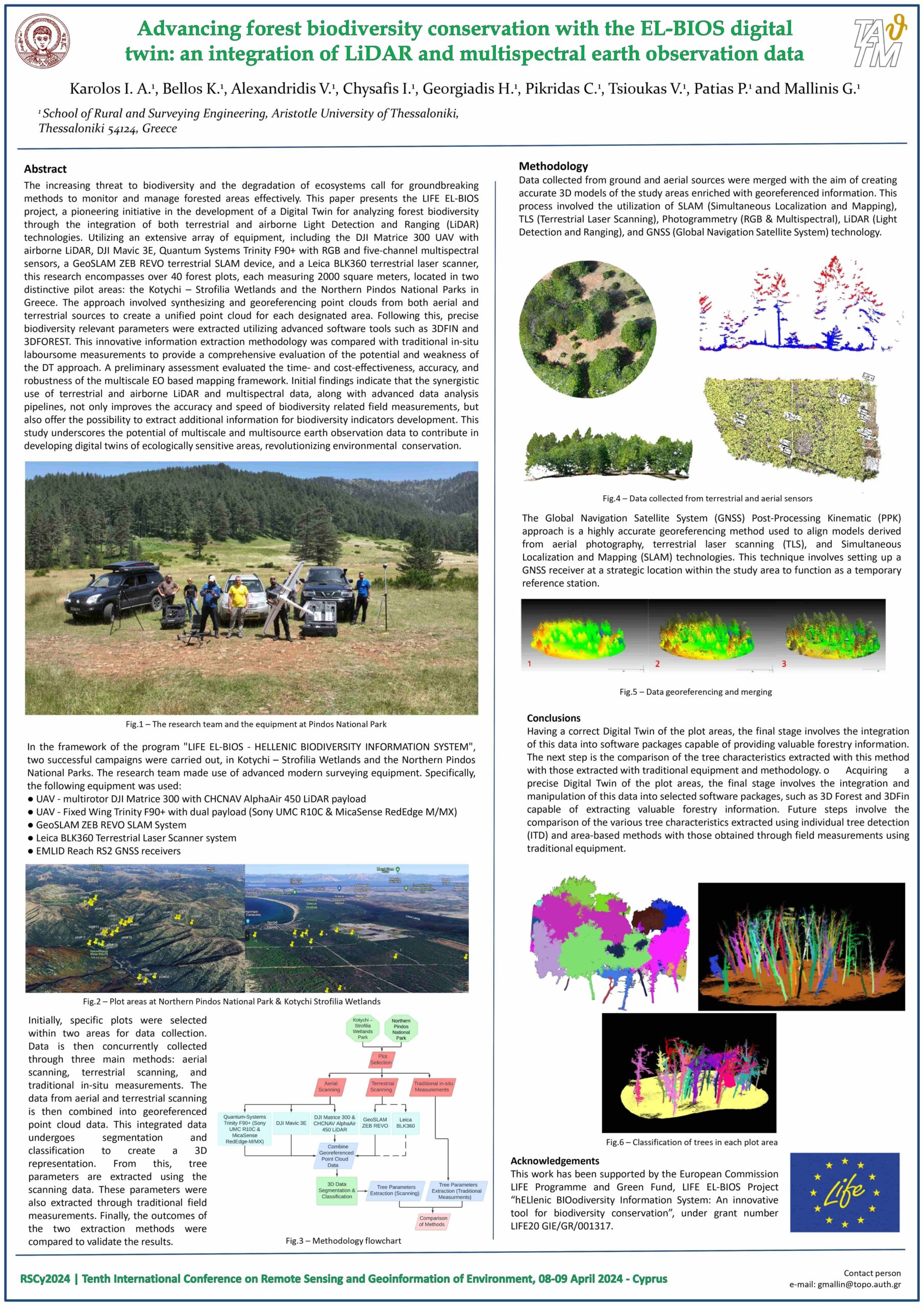
The increasing threat to biodiversity and the degradation of ecosystems call for groundbreaking methods to monitor and manage forested areas effectively. This paper presents the LIFE EL-BIOS project, a pioneering initiative in the development of a Digital Twin for analyzing forest biodiversity through the integration of both terrestrial and airborne Light Detection and Ranging (LiDAR) technologies.
Utilizing an extensive array of equipment, including the DJI Matrice 300 UAV with airborne LiDAR, DJI Mavic 3E, Quantum Systems Trinity F90+ with RGB and five-channel multispectral sensors, a GeoSLAM ZEB REVO terrestrial SLAM device, and a Leica BLK360 terrestrial laser scanner, this research encompasses over 40 forest plots, each measuring 2000 square meters, located in two distinctive pilot areas: the Kotychi – Strofilia Wetlands and the Northern Pindos National Parks in Greece.
The approach involved synthesizing and georeferencing point clouds from both aerial and terrestrial sources to create a unified point cloud for each designated area. Following this, precise biodiversity relevant parameters were extracted utilizing advanced software tools such as 3DFIN and 3DFOREST. This innovative information extraction methodology was compared with traditional in-situ laboursome measurements to provide a comprehensive evaluation of the potential and weakness of the DT approach.
A preliminary assessment evaluated the time- and cost-effectiveness, accuracy, and robustness of the multiscale EO based mapping framework. Initial findings indicate that the synergistic use of terrestrial and airborne LiDAR and multispectral data, along with advanced data analysis pipelines, not only improves the accuracy and speed of biodiversity related field measurements, but also offer the possibility to extract additional information for biodiversity indicators development.
This study underscores the potential of multiscale and multisource earth observation data to contribute in developing digital twins of ecologically sensitive areas, revolutionizing environmental conservation.
In the framework of the program “LIFE EL-BIOS – HELLENIC BIODIVERSITY INFORMATION SYSTEM”, two successful campaigns were carried out, in Kotychi – Strofilia Wetlands and the Northern Pindos National Parks. The research team made use of advanced modern surveying equipment. Specifically, the following equipment was used:
- UAV – multirotor DJI Matrice 300 with CHCNAV AlphaAir 450 LiDAR payload,
- UAV – Fixed Wing Trinity F90+ with dual payload (Sony UMC R10C & MicaSense RedEdge M/MX),
- GeoSLAM ZEB REVO SLAM System,
- Leica BLK360 Terrestrial Laser Scanner system,
- EMLID Reach RS2 GNSS receivers.
Initially, specific plots were selected within two areas for data collection. Data is then concurrently collected through three main methods: aerial scanning, terrestrial scanning, and traditional in-situ measurements. The data from aerial and terrestrial scanning is then combined into georeferenced point cloud data. This integrated data undergoes segmentation and classification to create a 3D representation. From this, tree parameters are extracted using the scanning data. These parameters were also extracted through traditional field measurements. Finally, the outcomes of the two extraction methods were compared to validate the results.
This work was implemented in the framework of the LIFE EL-BIOS project “hELlenic BIOdiversity Information System: An innovative tool for biodiversity conservation”. The LIFE EL-BIOS project (LIFE20 GIE/GR/001317) is co-financed by the LIFE Programme of the European Union and Green Fund.
Download the pdf: HERE